
Swathes of England are set to be hit by thunderstorms and heavy rain following the driest start to summer on modern record.
Flash flooding could lead to power cuts, hazardous driving conditions and transport delays across stretches of the country on Friday afternoon, the Met Office said.
Yellow weather warnings are in place across the East Midlands and East of England, London and the South East, and the South West from 2pm until the end of the day.
There's a #thunderstorm warning for parts of England today and some much-needed #rain. If you take any good photographs share them. #loveukweather pic.twitter.com/PU4pOcIFKa
— Met Office (@metoffice) July 20, 2018
Some areas could see up to 1.2in (30mm) of rain in an hour, with the risk of flooding increased as hard ground conditions mean water is initially less absorbed into the soil.
Rain is also forecast across Scotland and Northern Ireland through Friday.
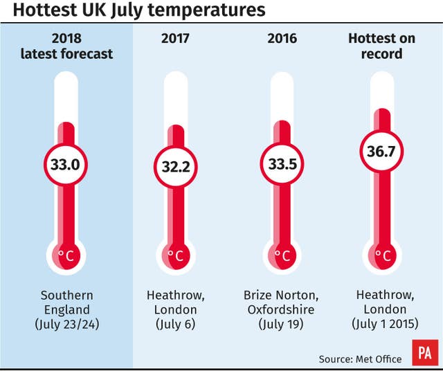
However, temperatures are set to remain in the high-20s across southern parts and could climb even higher going into the weekend.
The average rainfall for all areas of England, except the south west, was higher in the seven days to this Tuesday than the previous 21 days combined, the Met Office said.
The East of England has seen just 1% of its long-term average rainfall in July so far, while no region has had more than one-fifth.
The scale of the heatwave was illustrated in Nasa satellite images of England taken in both May and mid-July, where largely dark-green land has turned yellow-brown.
Meanwhile, United Utilities, which supplies the North West, is introducing a hosepipe ban from August 5 amid concern over low reservoir levels.
It has asked for permission to take more water from three lakes in Cumbria to safeguard supplies, applying for drought permits for Ullswater and Windermere and a drought order for Ennerdale.
Six areas of England have seen “exceptionally low” daily river flows over the past week and another six have seen “notably low” levels, according to data from the Environment Agency.
Overall, at two-thirds of “indicator sites” on rivers, levels are below normal for the time of year, and none are above normal.
Elsewhere, the Environment Agency has taken to aeration to sustain oxygen levels for fish in some rivers during the hot spell.
The UK as a whole saw only 19.5% of expected summer rainfall between June 1 and July 16, according to Met Office figures.
As of Wednesday, the UK having just 1.85in (47mm) of rain so far means it is the driest start to summer in modern records which date back to 1961, followed by 2013 with 2.3in (59mm) of rain.
Good morning, Luke here to answer all of your weather-related questions! The SE will stay largely dry initially, but increasing heat will trigger hit-and-miss thunderstorms later, whilst rain in the NW will push into south Wales and the Midlands: https://t.co/jtrhUzUBdR ^Luke pic.twitter.com/TL7XzSpMMM
— Met Office (@metoffice) July 20, 2018
Met Office meteorologist Aidan McGivern said: “The hottest air will be in the South East, with the heat and humidity combining to set off thunderstorms for Friday evening rush- hour.
“Tricky driving conditions, spray on roads, flash flooding, 30mm (1.2in) of rainfall in the space of an hour for some but hit-and-miss thunderstorms.
“There are also some outbreaks of rain for the South West and Wales as we wake up on Saturday – some useful rain for the gardens and the farms – but it soon starts to brighten up and dry up across large parts of the country.
“The sun does break through by the afternoon … leading again to heat and humidity in the South West, and once more that could set off a few thunderstorms as we end Saturday.”


Comments: Our rules
We want our comments to be a lively and valuable part of our community - a place where readers can debate and engage with the most important local issues. The ability to comment on our stories is a privilege, not a right, however, and that privilege may be withdrawn if it is abused or misused.
Please report any comments that break our rules.
Read the rules here